How
Precision Agriculture Can Save Time and Money
Precision farming,
smart agriculture, use of GPS and field sensors become more popular now a days,
farmers adopt these new technologies because they can save both time and money. Precision agriculture also sometimes called satellite or digital farming is basically the use of medium to
high resolution images (eg. Landsat 8 and Sentinel 2) and geographic
positioning system (GPS) to analyze and monitor the status and health of the
crops in the field.
This is done through the help of GIS and remote sensing software packages for analysis and product derivations such as yield and biomass potential, crop chlorophyll content, plant height and densities, soil moisture and spectral index such as NDVI or Normalized Difference Vegetation index, which is one of the most popular index when it comes to crop analysis and it has a wide range of application.
I
have listed a few ways on how precision agriculture works.
Precision
Agriculture using Farm Machineries and GPS
The demand for is
increasing rapidly due to the continuously growing population in the world and
one of the challenge in agriculture is how to increase the agricultural
production and sustainability. In spite of the continually growing technologies
most of the agriculture sector experienced shortage due to inappropriate management
of limited resources.
One solution to these events is the use of farm machineries
employed with geographic positioning system thereby implementing precision agriculture.
This method enables a site specific management system by relaying on spatial
data this also enables farmers to manage large farm areas with limited
manpower. Famous examples of these are the automated planters, fertilizer
applicators and sprayers which avoid over application thereby decreasing the
negative impacts in the environment.
Precision
Agriculture using Free Satellite Images
There are several free
satellite images that can be downloaded online and can be use by farmers for
precision agriculture but before I mention where to download these images let
me explain what are these free images and how to use it for precision
agriculture/farming. Basically satellite imagery are images acquired via
satellites (eg. Landsat and Sentinel). These satellites are equipped with
sensors which are able to capture multispectral image (visible to near-infrared) which are important
for agricultural purposes because this will enable us to generate spectral
indices such as:
·
Normalized Difference Vegetation Index
(NVDI)
·
Soil Adjusted vegetation Index (SAVI)
·
Enhanced Vegetation Index (EVI)
These spectral indices
represents the status of the crops in near real time and provide management
zones which helps farmers on deciding what areas to prioritize and what areas
to keep little attention.
Data
Sources
·
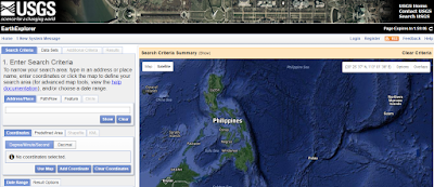
Landsat
Image from United StatesGeological Survey: is one of the famous open source
image that you can download in the net today. Landsat image has a 30 meter
resolution and consist of multi-spectral bands which you can use for your crop
image analysis.
 |
| Landsat website |
·
Sentinel
from
Copernicus Open Access Hub: is a mission
launched by European Space
Agency. Sentinel images can e downloaded for free by signing in or
creating an account in the given link above. Sentinel image is consist of 12
spectral bands where 4 of which are in 10 meter resolution (visible to
near-infrared) imagine the rich information that you can extract with this free
image for different agricultural purposes.
 |
| Sentinel Website |
·
Diwata
1 from PHL MICROSAT: is
first Philippine microsatellite under the PHL-Microsat Program. Although the
image distribution is still in its beta phase, individuals coming from non
government agencies, research and academic institution are allow to access the
image web browser and to download images given that individuals are signed up
and proved their affiliation on the said agencies and institutions but once the
full operation of this program takes place everyone can access image in this
program. Diwata 1 is equipped with High Precision telescope which able to
capture high resolution image with a resolution of about 3 meters, its sure
that this will become one of the best providers of high resolution image in the
future and will provide a wide range of application especially in the
agriculture sector in the Philippines.
 |
| PHL MICROSAT Website |
Precision
Agriculture via Drones
Drones gain popularity
more and more now a day whether it’s for photography, recreation and even for
agriculture. There are a lot of drones available online that can be use for
precision agriculture, but what are the things that drones can do in your farm?
- · Tree Count Estimation
- · Biomass estimation for yield prediction
- · Crop scouting (Insect pest & diseases monitoring)
- · Spray application
 |
| Agricultural Drone Spraying Sugarcane Field |


Golden Nugget Casino and Hotel - MapyRO
ReplyDeleteGolden Nugget 충청북도 출장샵 Casino and Hotel features a casino, 과천 출장마사지 an outdoor swimming pool, a bar and 파주 출장마사지 a 고양 출장마사지 Jacuzzi. There are 10 restaurants 동해 출장샵 on site, and a bowling alley is
Precision agriculture is a game-changer, and technology keeps pushing it forward. Agriculture drone mapping takes it a step further by giving farmers real-time insights into crop health and soil conditions. It’s amazing how data can help make farming more efficient!
ReplyDelete